

Images of Central Florida
Preview
Description
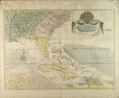
A map of Carolina, Florida and the Bahama Islands with the adjacent parts. Thought to be an original map for Catesby's Natural History. Scale of miles 60 to a degree.
Date
1731
Subjects
North Carolina -- Maps.; Caribbean Area -- Maps.; South Carolina -- Maps.; Georgia -- Maps.; Cuba -- Maps.; Bahamas -- Maps.; Louisiana -- Maps.; Yucatan Peninsula -- Maps.; Puerto Rico -- Maps.; Bermuda Islands -- Maps.; Florida -- Historical geopgrahy -- Maps.
Subject-Topic
Maps
Coverage-Spatial
North Carolina; South Carolina; Georgia; Caribbean; Cuba; Bahamas; Louisiana
Coverage-Temporal
18th century
Side of Image
Front of Postcard
Repository
Rollins College
Repository Collection
Archives and Special Collections
Identifier
DP0003859; 20309168
Size of Original Image
43 x 60 cm.
Rights Statement
All rights to images are held by the respective holding institution. This image is posted publicly for non-profit educational uses, excluding printed publication. To purchase copies of images and/or for copyright information contact the respective holding institution.
Digital Publisher
Electronically reproduced by the Digital Services unit of the University of Central Florida Libraries, Orlando, 2005.
Digital Reproduction Specifications
This image was derived from an uncompressed TIFF image scanned at a minimum of 400 dpi.
Recommended Citation
Catesby, Mark, "A Map of Carolina, Florida and the Bahama Islands With the Adjacent Parts" (1731). Images of Central Florida. 138.
https://stars.library.ucf.edu/cfm-images/138