

Images of Central Florida
Preview
Description
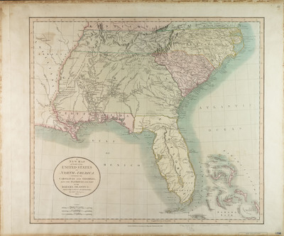
A new map of part of the United States of North America: containing the Carolinas and Georgia, also the Floridas and part of the Bahama Islands &c.- from the latest authorities by John Cary, engraver. The map relief is shown pictorially. Map is from Cary's new universal atlas: J. Cary. London: J. Cary, 1808, map no. 57. Map is hand colored. Map scale [ca. 1:4,245,120]. Inscribed on back of map: 28 Ja 37 Stevens 6306.
Date
1806
Subjects
Florida -- Maps.- South Atlantic States -- Maps.; Bahamas -- Maps.; Florida -- History -- To 1821 Maps.; South Atlantic States -- Historical geography -- Maps.
Subject-Topic
Maps
Coverage-Spatial
Carolinas; Georgia; Florida; Bahamas
Coverage-Temporal
19th century
Side of Image
Front of Postcard
Repository
Rollins College
Repository Collection
Archives and Special Collections
Identifier
DP0004443; 24599370
Size of Original Image
44 x 50 cm.
Rights Statement
All rights to images are held by the respective holding institution. This image is posted publicly for non-profit educational uses, excluding printed publication. To purchase copies of images and/or for copyright information contact the respective holding institution.
Digital Publisher
Electronically reproduced by the Digital Services unit of the University of Central Florida Libraries, Orlando, 2005.
Digital Reproduction Specifications
This image was derived from an uncompressed TIFF image scanned at a minimum of 400 dpi.
Recommended Citation
Cary, John, "A New Map of Part of the United States of North America" (1806). Images of Central Florida. 140.
https://stars.library.ucf.edu/cfm-images/140