

Images of Central Florida
Title
Preview
Description
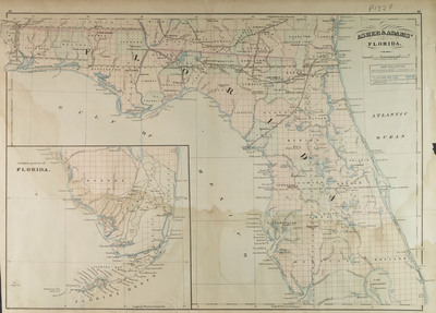
Asher and Adam's map of Florida, Prime meridians: Greenwich and Washington D.C. Contains inset of Southern part of Florida. Map "Entered according ot act of Congress in the year 1871 by Asher and Adams in the Office of the Librarian of Congress in Washington. Map scale [1:1,267,200] 20 miles to an inch. (W 87°20'00"--W 80°00'00"/N 31°10'00"--N 27°00'00").
Date
1871
Subjects
Florida -- Maps.; Railroads -- Florida -- Maps.; Florida -- Administrative and political divisions -- Maps.; Florida -- Historical geography -- Maps.
Subject-Topic
Maps
Coverage-Spatial
Florida
Coverage-Temporal
19th Century
Side of Image
Front of Postcard
Repository
Rollins College
Repository Collection
Archives and Special Collections
Identifier
DP0003816; 55490290
Size of Original Image
41 x 57 cm.
Rights Statement
All rights to images are held by the respective holding institution. This image is posted publicly for non-profit educational uses, excluding printed publication. To purchase copies of images and/or for copyright information contact the respective holding institution.
Digital Publisher
Electronically reproduced by the Digital Services unit of the University of Central Florida Libraries, Orlando, 2005.
Digital Reproduction Specifications
This image was derived from an uncompressed TIFF image scanned at a minimum of 400 dpi.
Recommended Citation
Asher and Adams, "Asher and Adams' Florida" (1871). Images of Central Florida. 150.
https://stars.library.ucf.edu/cfm-images/150