

Images of Central Florida
Preview
Photographer
Unknown;
Keywords
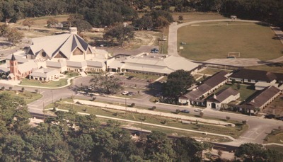
Aerial View; 1993 church facility; St. Luke's Lutheran School; Track; Athletic track; Founders Hall; Picnic grounds; State Road 426
Description
This aerial photo, taken from slightly southwest of the church, shows St, Luke's campus as it appeared in the mid-1990s. The new sanctuary had been completed and dedicated in 1993; St. Luke's School still operated K-8th grade classes in the structure which was originally built in 1947 and expanded several times over the next 50 years. Founders Hall (gymnasium), built in 1979, sits between the church and the school; an athletic track, created the same year, is placed farther back on the campus, as are playground and picnic areas. State Road 426 was still a 2 lane (undivided) highway when this photo was taken.
Date
mid 1990s
Coverage-Spatial
Seminole County, Fla.
Number of Images
1
Side of Image
Front of Postcard
Repository
St. Luke's Lutheran Church and School; DSpace at St. Luke's
Repository Collection
Digital Archives of St. Luke's Lutheran Church.; D. Expanded Church 1993-2011;
Identifier
DP0020484
Rights Statement
All rights to images are held by the respective holding institution. This image is posted publicly for non-profit educational uses, excluding printed publication. For permission to reproduce images and/or for copyright information contact St. Luke’s Lutheran Church at 2021 W SR 426, Oviedo, FL 32765 or (407) 365-3408.
Digital Publisher
St. Luke's Lutheran Church, Oviedo, Fla.
Digital Reproduction Specifications
Jpeg2000 images were derived from previously scanned jpeg images.
Recommended Citation
"Aerial View of St. Luke's Church and School. Mid-1990s" (1990). Images of Central Florida. 432.
https://stars.library.ucf.edu/cfm-images/432
Keywords
Aerial View; 1993 church facility; St. Luke's Lutheran School; Track; Athletic track; Founders Hall; Picnic grounds; State Road 426