

Images of Central Florida
Preview
Contributors
Johnston, Alexander Keith, 1804-1871.; W. and A.K. Johnston Limited.; John Murray (Firm).
Description
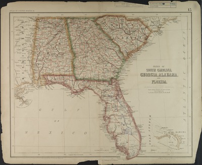
Map of South Carolina, Georgia, Alabama, and Florida by H.D. Rogers and A. Keith Johnston; engraved by W.andand A.K. Johnston, Edinburgh. Map denotes counties and districts, relief shown by hachures. In the upper margin of the map is printed: Atlas of United State & Map was "Entered in Sta. Hall, London and according to act of Congress in the year 1857 by H.D. Rogers, in the Clerks office of the District of Court of Massachusetts. Map appears in: Atlas of the United States of North America (London: Edward Stanford, c1857) plate 15. Map scale [1:3,450,000] 54 1/2 miles to 1".
Date
1857
Subjects
Mississippi -- Maps.; Alabama -- Maps.; Georgia -- Maps.; South Carolina -- Maps.; Florida -- Maps.; Southern States -- Administrative and political divisions -- Maps.; Fortification -- Southern States.; Southern States -- Historical geography -- Maps.
Coverage-Spatial
South Carolina; Georgia; Alabama; Florida
Coverage-Temporal
19th century
Side of Image
Front of Postcard
Repository
Rollins College
Repository Collection
Archives and Special Collections
Identifier
DP0003923; 55101735
Size of Original Image
33 x 39 cm.
Rights Statement
All rights to images are held by the respective holding institution. This image is posted publicly for non-profit educational uses, excluding printed publication. To purchase copies of images and/or for copyright information contact the respective holding institution.
Digital Publisher
Electronically reproduced by the Digital Services unit of the University of Central Florida Libraries, Orlando, 2005.
Digital Reproduction Specifications
This image was derived from an uncompressed TIFF image scanned at a minimum of 400 dpi.
Recommended Citation
Rogers, Henry D. and Johnston, Alexander Keith, "States of South Carolina, Georgia, Alabama, and Florida." (1857). Images of Central Florida. 838.
https://stars.library.ucf.edu/cfm-images/838