
Preview
Attribution
Image courtesy of the Florida Historical Society
Subjects
Atlases; Cartographers; Cartography--History--16th century; Cartographic materials; Ortelius, Abraham, 1527-1598; America--Maps--Early works to 1800; Cartography--Early works to 1800; Map printing; Maps; Early Maps; Bry, Theodor de, 1528-1598; Le Moyne de Morgues, Jacques, 1533?-1588; Colonization; Civilization; Florida--History, Local
Abstract
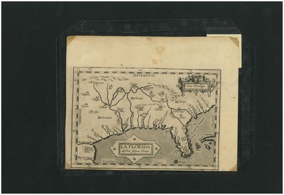
Ortelius (artifact image), from A History of Central Florida: Podcast, Episode 06: Early Maps of Florida. Episode 6 features early maps of Florida.
Contributor (Linked data)
Florida Historical Society (VIAF); Florida Historical Society (LC)
Identifier
1572_Ortelius
Language
English
Collection
Title - Alternative
Ortelius, from A History of Central Florida: Podcast, Episode 06: Early Maps of Florida
Preferred Title
A History of Central Florida: Podcast, Episode 06: Early Maps of Florida
STARS Citation
"Ortelius" (2014). All Museum Images. Image 33.
https://stars.library.ucf.edu/ahistoryofcentralfloridaimages/33
Keywords
Episode 06; Early Maps of Florida; 16th century maps of Florida; Atlases, American; Cartographic process; European experiences in Florida; Abraham Ortelius; Theatre De l'Univers; Theatre of the World; Atlas of the New World; Early map printing process; Theodore De Bry; Jacques le Moyne; Chicora; Artifacts; Central Florida
Accessibility Statement
This item was created or digitized prior to April 24, 2027, or is a reproduction of legacy media created before that date. It is preserved in its original, unmodified state specifically for research, reference, or historical recordkeeping. In accordance with the ADA Title II Final Rule, the University Libraries provides accessible versions of archival materials upon request. To request an accommodation for this item, please submit an accessibility request form.