

Images of Central Florida
Preview
Contributors
F. Bourquin and Co.
Description
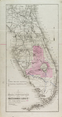
Map of Atlantic and Gulf Coast Canal and Okeechobee Land Co. land purchases showing drainage territory (colored in pink)- compiled from surveys by J.M. Kreamer, chief engineer. Second copy of the map in Rollins College Archive and Special Collections has added in ink "The Democrat Expedition (numbered roman numeral I) and the Ingraham Expedition (numbered roman numeral II)- 1892.-- Also denoted on the map are railroads, counties, and forts.---
Date
1800s
Subjects
Railroads -- Florida -- Maps.; Canals -- Florida -- Maps.; Atlantic and Gulf Coast Canal -- Maps.; Okeechobee Land Co.--- Maps.; Fortification -- Florida -- Maps.; Administrative and political divisions -- Florida -- Maps.; Drainage -- Florida -- Maps.; Florida -- Historical geography -- Maps.
Subject-Topic
Maps
Coverage-Spatial
Florida
Coverage-Temporal
19th century
Side of Image
Front of Postcard
Repository
Rollins College
Repository Collection
Archives and Special Collections
Identifier
DP0003817; 57358006
Size of Original Image
39 x 20 cm.
Rights Statement
All rights to images are held by the respective holding institution. This image is posted publicly for non-profit educational uses, excluding printed publication. To purchase copies of images and/or for copyright information contact the respective holding institution.
Digital Publisher
Electronically reproduced by the Digital Services unit of the University of Central Florida Libraries, Orlando, 2005.
Digital Reproduction Specifications
This image was derived from an uncompressed TIFF image scanned at a minimum of 400 dpi.
Recommended Citation
Kreamer, J. M., "Atlantic and Gulf Coast Canal and Okeechobee Land Co. Showing Drainage Territory Compiled From Recent Surveys" (1800). Images of Central Florida. 134.
https://stars.library.ucf.edu/cfm-images/134