

Images of Central Florida
Preview
Contributors
Sayer, Robert, 1725-1794.
Description
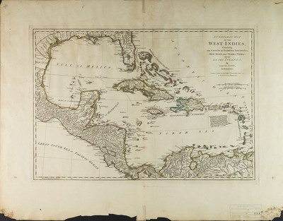
A compleat map of the West Indies containing the coasts of Florida, Louisiana, New Spain, and Terra Firma: with all the islands. Map is hand colored, relief is shown pictorially, and longitiude is from Ferro.- Map also includes sections of Central America and South America. Map comes from Robert Sayer and John Bennett's The American military pocket atlas [1776]- Map scale [1:9,000,000]
Date
1774
Subjects
Caribbean Area -- Maps -- Early works to 1800.; Florida -- History -- English colony, 1763-1784 -- Maps.; Central America -- Maps.; South America -- Maps.; Caribbean Area -- Historical geography -- Maps.
Subject-Topic
Maps
Coverage-Spatial
West Indies; Florida; Louisiana; New Spain; Terra Firma; Central America; South America
Coverage-Temporal
19th century
Side of Image
Front of Postcard
Repository
Rollins College
Repository Collection
Archives and Special Collections
Identifier
DP0004073; 5412808
Size of Original Image
31 x 45 cm.
Rights Statement
All rights to images are held by the respective holding institution. This image is posted publicly for non-profit educational uses, excluding printed publication. To purchase copies of images and/or for copyright information contact the respective holding institution.
Digital Publisher
Electronically reproduced by the Digital Services unit of the University of Central Florida Libraries, Orlando, 2005.
Digital Reproduction Specifications
This image was derived from an uncompressed TIFF image scanned at a minimum of 400 dpi.
Disciplines
Photography
Recommended Citation
Dunn, Samuel, "A Compleat Map of the West Indies: Containing the Coasts of Florida, Louisiana, New Spain, and Terra Firma: With All the Islands" (1774). Images of Central Florida. 139.
https://stars.library.ucf.edu/cfm-images/139