

Images of Central Florida
Preview
Contributors
Seminole County Chamber of Commerce.
Description
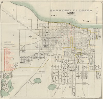
Foldable map which contains general information about the city of Sanford, including transportation, population, and climate. Three maps are included in this pamphlet: a map of Seminole County as of 1940, which includes a key which denotes good fishing, boats, bait, and scenic drives. A map of the state of Florida is shown which marks road routes leading to Sanford. A map of the city of Sanford as of 1935 notes scenic drive routes and places of interest.
Date
1942
Subjects
Sanford (Fla.) -- Maps, Tourist; Scenic byways -- Florida -- Sanford -- Maps.; Scenic byways -- Florida -- Seminole County -- Maps; Seminole County (Fla.) -- Maps, Tourist; Florida -- Maps, Tourist
Coverage-Spatial
Seminole County, Fla.; Slavia (Fla.)); Sanford (Fla.)
Number of Images
2 images
Side of Image
Back of Postcard
Repository
Sanford Museum
Identifier
DP0008184
Size of Original Image
full sheet 58 cm. x 48 cm.; folded 44 cm. x 46 cm. or smaller
Rights Statement
All rights to images are held by the respective holding institution. This image is posted publicly for non-profit educational uses, excluding printed publication. To purchase copies of images and/or for copyright information contact the respective holding institution.
Digital Publisher
Electronically reproduced by the Digital Services unit of the University of Central Florida Libraries, Orlando, 2011.
Funding source
RICHES 2011
Digital Reproduction Specifications
Jpeg2000 images were derived from 400 dpi tiffs scanned on an Avision FB 6080E Book-edge Scanner.
Date Digitized
2011-01
Recommended Citation
Williams, Fred T. and Seminole County Chamber of Commerce., "Maps of city of Sanford, Fla., Seminole County, Fla. and State of Florida" (1942). Images of Central Florida. 2447.
https://stars.library.ucf.edu/cfm-images/2447
Accessibility Statement
This item was created or digitized prior to April 24, 2027, or is a reproduction of legacy media created before that date. It is preserved in its original, unmodified state specifically for research, reference, or historical recordkeeping. In accordance with the ADA Title II Final Rule, the University Libraries provides accessible versions of archival materials upon request. To request an accommodation for this item, please submit an accessibility request form.