

Images of Central Florida
Preview
Photographer
Unknown;
Contributors
Breese, Samuel, 1802-1873
Description
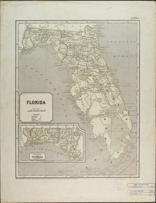
Map of Florida depicting roads, harbors and rivers. The Prime meridians for the map are: Greenwich and Washington, D.C. Contains inset of West part of Florida at the same scale as the main map. The map was "Entered according to act of Congress in 1842 by Sidney E. Morse and Samuel Breese. Map scale [ca. 1:2,028,000]
Date
1842
Subject-Topic
Maps
Coverage-Spatial
Florida
Coverage-Temporal
19th century
Side of Image
Front of Postcard
Repository
Rollins College
Repository Collection
Archives and Special Collections
Identifier
DP0003837; 36487438
Size of Original Image
36 x 28 cm.
Rights Statement
All rights to images are held by the respective holding institution. This image is posted publicly for non-profit educational uses, excluding printed publication. To purchase copies of images and/or for copyright information contact the respective holding institution.
Digital Publisher
Electronically reproduced by the Digital Services unit of the University of Central Florida Libraries, Orlando, 2005.
Digital Reproduction Specifications
This image was derived from an uncompressed TIFF image scanned at a minimum of 400 dpi.
Recommended Citation
Morse, Sidney E. and Breese, Samuel, "Florida." (1842). Images of Central Florida. 823.
https://stars.library.ucf.edu/cfm-images/823
Accessibility Statement
This item was created or digitized prior to April 24, 2027, or is a reproduction of legacy media created before that date. It is preserved in its original, unmodified state specifically for research, reference, or historical recordkeeping. In accordance with the ADA Title II Final Rule, the University Libraries provides accessible versions of archival materials upon request. To request an accommodation for this item, please submit an accessibility request form.