

Images of Central Florida
Preview
Contributors
Chapman and Chase.; Photo Electro Company.
Description
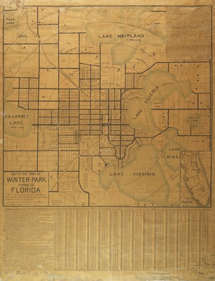
Map of Winter Park, Orange County, Florida, includes land development information: lot number, street frontage in feet, number of orange trees that can be planted on each lot, and price, as provided by Chapman and Chase two of the founders and developers of Winter Park.and(http:and/www.wppl.org/wphistory/FoundersBio.htm) Contains inset map of Florida. Layout description as found on the map "The territory represented is 2 1/2 miles from North to South, and the same from East to West embracing 6 sq. miles. Circles are 1/4 mile apart with Winter Park Depot as the centre."
Date
1884
Subjects
Winter Park (Fla.) -- Maps.; Chapman - Chase -- Maps.; Land companies -- Florida -- Winter Park -- Maps.; Real estate development -- Winter Park -- Florida.; Real property -- Florida -- Winter Park -- Maps.; Streets -- Florida -- Winter Park -- Maps.
Coverage-Spatial
Winter Park (Fla.)
Coverage-Temporal
19th century
Side of Image
Front of Postcard
Repository
Rollins College
Repository Collection
Archives and Special Collections
Identifier
DP0003871; 57358128
Size of Original Image
57 x 46 cm.
Rights Statement
All rights to images are held by the respective holding institution. This image is posted publicly for non-profit educational uses, excluding printed publication. To purchase copies of images and/or for copyright information contact the respective holding institution.
Digital Publisher
Electronically reproduced by the Digital Services unit of the University of Central Florida Libraries, Orlando, 2005.
Digital Reproduction Specifications
This image was derived from an uncompressed TIFF image scanned at a minimum of 400 dpi.
Recommended Citation
Robinson, S. A., "Map of the town of Winter Park, Orange County, Florida." (1884). Images of Central Florida. 834.
https://stars.library.ucf.edu/cfm-images/834
Accessibility Statement
This item was created or digitized prior to April 24, 2027, or is a reproduction of legacy media created before that date. It is preserved in its original, unmodified state specifically for research, reference, or historical recordkeeping. In accordance with the ADA Title II Final Rule, the University Libraries provides accessible versions of archival materials upon request. To request an accommodation for this item, please submit an accessibility request form.