

Images of Central Florida
Preview
Contributors
Chief Press; Central Title and Trust Co.
Description
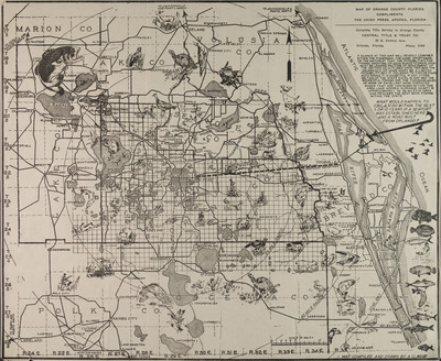
Map of Orange County, Florida and surrounding counties designed for luring tourists including fisherman, game sportsmen, and general travelers interested in seeing or capturing various types of game and wildlife in general. Map denotes types of animals that can be seen or caught throughout the region by inclusion of pictures of those animals. Inscribed on back of map in pencil is approximate date of map and id number given to map by the History Center. Map was made in the 1920s and provided by the Central Title and Trust Co. of Orlando, located at 25 E. Central Ave. The map was printed by the Chief Press, Apopka, Florida, and was compiled and drawn by A. Clague.
Date
1920s
Subjects
Orange County (Fla.) -- Maps.; Florida -- Administrative and political divisions -- Maps.; Hunting -- Florida -- Maps.; Fishing -- Florida -- Maps.; Florida -- Maps, Tourist.; Orange County (Fla.) -- Historical geography -- Maps.
Coverage-Spatial
Orange County (Fla.); Brevard County (Fla.); Osceola County (Fla.); Polk County (Fla.); Lake County (Fla.); Marion County (Fla.); Volusia County (Fla.)
Coverage-Temporal
20th century
Side of Image
Front of Postcard
Repository
Orange County Regional History Center
Identifier
DP0004083
Rights Statement
All rights to images are held by the respective holding institution. This image is posted publicly for non-profit educational uses, excluding printed publication. To purchase copies of images and/or for copyright information contact the respective holding institution.
Digital Publisher
Electronically reproduced by the Digital Services unit of the University of Central Florida Libraries, Orlando, 2005.
Digital Reproduction Specifications
This image was derived from an uncompressed TIFF image scanned at a minimum of 400 dpi.
Date Digitized
2005-08-03
Disciplines
Photography
Recommended Citation
Clague, A., "Map of Orange County, Florida" (1920). Images of Central Florida. 84.
https://stars.library.ucf.edu/cfm-images/84
Accessibility Statement
This item was created or digitized prior to April 24, 2027, or is a reproduction of legacy media created before that date. It is preserved in its original, unmodified state specifically for research, reference, or historical recordkeeping. In accordance with the ADA Title II Final Rule, the University Libraries provides accessible versions of archival materials upon request. To request an accommodation for this item, please submit an accessibility request form.