

Images of Central Florida
Preview
Description
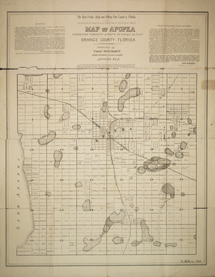
1886 map of Apopka, Fla. showing streets, rail lines, city blocks, properties with owner names. Text on map addresses population, railroads, businesses, schools and churches, geography, and business potential of area. Map published by Page McKinney real estate loan agent. The name of G.E. Hunt, developer appears in lower right hand corner.
Date
1886
Subjects
Apopka (Fla.) -- Maps.; Real estate development -- Florida -- Apopka -- Maps.
Subject-Topic
Maps
Coverage-Spatial
Apopka (Fla.)
Coverage-Temporal
19th century
Side of Image
Front of Postcard
Repository
Orange County Regional History Center
Identifier
DP0004751
Size of Original Image
63 x 48 cm.
Rights Statement
All rights to images are held by the respective holding institution. This image is posted publicly for non-profit educational uses, excluding printed publication. To purchase copies of images and/or for copyright information contact the respective holding institution.
Digital Publisher
Electronically reproduced by the Digital Services unit of the University of Central Florida Libraries, Orlando, 2006.
Digital Reproduction Specifications
This image was derived from an uncompressed TIFF image scanned at a minimum of 400 dpi.
Date Digitized
2006-03-01
Disciplines
Photography
Recommended Citation
McKinney, Page, "Map of Apopka" (1886). Images of Central Florida. 130.
https://stars.library.ucf.edu/cfm-images/130
Accessibility Statement
This item was created or digitized prior to April 24, 2027, or is a reproduction of legacy media created before that date. It is preserved in its original, unmodified state specifically for research, reference, or historical recordkeeping. In accordance with the ADA Title II Final Rule, the University Libraries provides accessible versions of archival materials upon request. To request an accommodation for this item, please submit an accessibility request form.