

Images of Central Florida
Preview
Contributors
Gentlemen's magazine.
Description
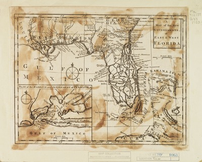
Map of the new governments of East and West Florida, from Gentlemen's magazine, v. 33, November 1763, p. 552, with a Prime Meridian of London. Contains inset plan of the harbour and settlement of Pensacola, scale (ca. 1:420,000) Map scale (ca. 1:6,100,000)Inscribed on back of map: 8 June 36 Todd #5192.
Date
1763
Subjects
Southern States -- Maps -- Early works to 1800.; Pensacola Bay Region (Fla.) -- Maps -- Early works to 1800.; Florida -- Maps -- Early works to 1800.; Bahamas -- Early works to 1800 -- Maps.; Cuba -- Early works to 1800 -- Maps.; Florida --Historical geography -- Maps.
Coverage-Spatial
Southern States; Florida; Pensacola (Fla.)
Side of Image
Front of Postcard
Repository
Rollins College
Repository Collection
Archives and Special Collections
Identifier
DP0003809; 21842746
Size of Original Image
18 x 24 cm.
Rights Statement
All rights to images are held by the respective holding institution. This image is posted publicly for non-profit educational uses, excluding printed publication. To purchase copies of images and/or for copyright information contact the respective holding institution.
Digital Publisher
Electronically reproduced by the Digital Services unit of the University of Central Florida Libraries, Orlando, 2005.
Digital Reproduction Specifications
This image was derived from an uncompressed TIFF image scanned at a minimum of 400 dpi.
Recommended Citation
Gibson, John, "A Map of the New Governments of East - West Florida" (1763). Images of Central Florida. 153.
https://stars.library.ucf.edu/cfm-images/153
Accessibility Statement
This item was created or digitized prior to April 24, 2027, or is a reproduction of legacy media created before that date. It is preserved in its original, unmodified state specifically for research, reference, or historical recordkeeping. In accordance with the ADA Title II Final Rule, the University Libraries provides accessible versions of archival materials upon request. To request an accommodation for this item, please submit an accessibility request form.