

Images of Central Florida
Preview
Description
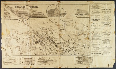
Birds-eye-view map of Orlando, Florida, showing streets, street names, rail lines, structures and lakes. Includes advertisements.
Date
1890
Subjects
Orlando (Fla.) -- Historical geography -- Maps.; Orlando (Fla.) -- Maps.; Streets -- Florida -- Orlando.; Buildings -- Florida --Orlando.; Railroads -- Florida -- Orlando.; Lakes -- Florida -- Orlando.; Advertising -- Florida -- Orlando.; Business Enterprises -- Florida -- Orlando.
Coverage-Spatial
Orlando (Fla.)
Coverage-Temporal
19th century
Number of Images
2 images
Side of Image
Front of Postcard
Repository
Orange County Regional History Center
Identifier
DP0003967
Rights Statement
All rights to images are held by the respective holding institution. This image is posted publicly for non-profit educational uses, excluding printed publication. To purchase copies of images and/or for copyright information contact the respective holding institution.
Digital Publisher
Electronically reproduced by the Digital Services unit of the University of Central Florida Libraries, Orlando, 2005.
Digital Reproduction Specifications
This image was derived from an uncompressed TIFF image scanned at a minimum of 400 dpi.
Recommended Citation
"1890 Orlando, Florida: county seat of Orange County." (1890). Images of Central Florida. 1992.
https://stars.library.ucf.edu/cfm-images/1992
Accessibility Statement
This item was created or digitized prior to April 24, 2027, or is a reproduction of legacy media created before that date. It is preserved in its original, unmodified state specifically for research, reference, or historical recordkeeping. In accordance with the ADA Title II Final Rule, the University Libraries provides accessible versions of archival materials upon request. To request an accommodation for this item, please submit an accessibility request form.