

Images of Central Florida
Preview
Description
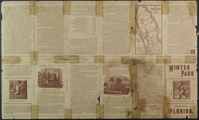
Map of the town of Winter Park, Orange County, Florida, 1883, includes inset map of Florida. Map also includes information on local lakes, and location of orange trees. Scale: lot 509 and 30 x 54 sq. feet and 1 acre; lot 110 and 100 x 143 ft. and 1/3 acre. Contained on the back of the map is information on Winter Park, its climate and health benefits of living in such a climate, and also information on boarding houses and hotels.
Date
1884
Subjects
Winter Park (Fla.) -- Maps.; Winter Park (Fla.) -- Description and travel.; Land tenure -- Florida -- Winter Park -- Maps.; Orange growers -- Florida -- Winter Park -- Maps.; Florida -- Maps.; Winter Park (Fla.) -- Climate.; Hotels -- Winter Park (Fla.).; Real property -- Florida -- Winter Park.; Florida -- Historical geography -- Winter Park -- Maps.
Subject-Topic
Maps
Coverage-Spatial
Florida; Winter Park (Fla.)
Coverage-Temporal
19th century
Number of Images
2 images
Side of Image
Back of Postcard
Repository
Rollins College
Repository Collection
Archives and Special Collections
Identifier
DP0003870; 57362961
Size of Original Image
27 x 23 cm.
Rights Statement
All rights to images are held by the respective holding institution. This image is posted publicly for non-profit educational uses, excluding printed publication. To purchase copies of images and/or for copyright information contact the respective holding institution.
Digital Publisher
Electronically reproduced by the Digital Services unit of the University of Central Florida Libraries, Orlando, 2005.
Digital Reproduction Specifications
This image was derived from an uncompressed TIFF image scanned at a minimum of 400 dpi.
Recommended Citation
Chapman and Chase., "Winter Park, Orange County, Florida." (1884). Images of Central Florida. 2396.
https://stars.library.ucf.edu/cfm-images/2396
Accessibility Statement
This item was created or digitized prior to April 24, 2027, or is a reproduction of legacy media created before that date. It is preserved in its original, unmodified state specifically for research, reference, or historical recordkeeping. In accordance with the ADA Title II Final Rule, the University Libraries provides accessible versions of archival materials upon request. To request an accommodation for this item, please submit an accessibility request form.