

Images of Central Florida
Preview
Contributors
J. J. Stoner, Madison, Wis.
Description
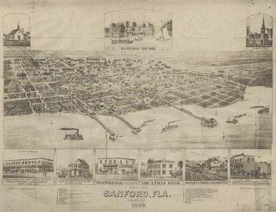
Hand-drawn map of the bird's-eye view of Sanford, Florida, from 1884. Depicts the city's blocks, street names, and homes and businesses that were inhabiting Sanford in 1884. Also shows Lake Monroe with steamships and sail boats afloat. Some more important buildings have been hand-drawn, including the Presbyterian Church, the Sanford House Hotel, the Episcopal Chruch, A. E. Philips Drugstore, Florida Land and Colonization Company office, Trafford & Hardware Co., the Lyman Bank, the South Florida Railroad Depot, and H. B. Lord's jewelry store. Throughout the map are small numbers that have been written on, and at the bottom of the map is an index with the corresponding house/building shown.
Date
ca. 1884
Subjects
Pictorial maps -- Florida -- Sanford; Florida Land and Colonization Company (Sanford, Fla.); South Florida Railroad Company
Subject-Personal Names
Beck, Charles H. (1853-1898); Lord, Henry B.; Magruder, James Bailey, Sr. (1859-1925); Murray, W. A.; Phelps, Lyman; Philips, Albert Edwin (1845-1920); Trafford, Edward Robert (1839-1906)
Coverage-Spatial
Sanford (Fla.)
Number of Images
1 image
Side of Image
Front of Postcard
Repository
Sanford Museum
Identifier
DP0010700
Size of Original Image
60 cm. x 47 cm.
Rights Statement
All rights to images are held by the respective holding institution. This image is posted publicly for non-profit educational uses, excluding printed publication. To purchase copies of images and/or for copyright information contact the respective holding institution.
Digital Publisher
Electronically reproduced by the Digital Services unit of the University of Central Florida Libraries, Orlando, 2011.
Funding source
RICHES 2011
Digital Reproduction Specifications
Jpeg2000 images were derived from 400 dpi tiffs scanned on an Avision FB 6080E Book-edge Scanner.
Date Digitized
2011-05
Recommended Citation
Beck & Pauli, Litho., Milwaukee, Wis., "Bird's Eye View of Sanford, Fla., Orange Co., 1884" (1884). Images of Central Florida. 2448.
https://stars.library.ucf.edu/cfm-images/2448
Accessibility Statement
This item was created or digitized prior to April 24, 2027, or is a reproduction of legacy media created before that date. It is preserved in its original, unmodified state specifically for research, reference, or historical recordkeeping. In accordance with the ADA Title II Final Rule, the University Libraries provides accessible versions of archival materials upon request. To request an accommodation for this item, please submit an accessibility request form.