

Images of Central Florida
Preview
Photographer
Unknown;
Keywords
Roadmap
Description
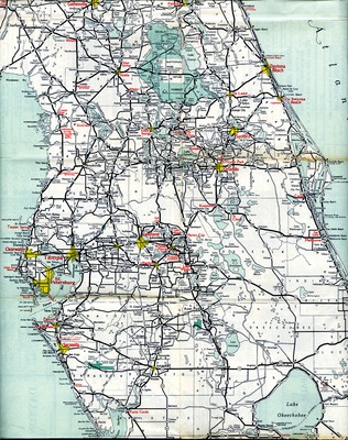
Roadmap of Florida, c. 1955. Offers a look back at Central FL before Interstates 4 or 95 were constructed. It also precedes the construction of UCF and SR434 which has become an arterial road serving the Oviedo area. The Greeneway (#417) would not be built for another 40 years. The community of Slavia is not named on this map, but is located about halfway between Sanford and Orlando, slightly south of the city of Oviedo.; Portion of larger roadmap contributed to St. Luke's Archive was scanned on Epson XL10000 in November, 2014
Date
1955
Coverage-Spatial
Seminole County, Fla.
Coverage-Temporal
1946
Side of Image
Front of Postcard
Repository
St. Luke's Lutheran Church and School; DSpace at St. Luke's
Repository Collection
St. Luke's Lutheran Church: Brick Church 1939-1956;
CFM Storyline
People; Places; Social Life
Identifier
DP0015795
Rights Statement
All rights to images are held by the respective holding institution. This image is posted publicly for non-profit educational uses, excluding printed publication. For permission to reproduce images and/or for copyright information contact St. Luke’s Lutheran Church at 2021 W SR 426, Oviedo, FL 32765 or (407) 365-3408.
Digital Publisher
St. Luke's Lutheran Church, Oviedo, Fla.
Digital Reproduction Specifications
Jpeg2000 images were derived from previously scanned jpeg images.
Date Digitized
2011-01-01
Recommended Citation
"Road Map of Florida, c. 1955" (1955). Images of Central Florida. 283.
https://stars.library.ucf.edu/cfm-images/283
Keywords
Roadmap
Accessibility Statement
This item was created or digitized prior to April 24, 2027, or is a reproduction of legacy media created before that date. It is preserved in its original, unmodified state specifically for research, reference, or historical recordkeeping. In accordance with the ADA Title II Final Rule, the University Libraries provides accessible versions of archival materials upon request. To request an accommodation for this item, please submit an accessibility request form.