

Images of Central Florida
Preview
Photographer
Unknown;
Contributors
Krivosova, Janka
Keywords
Aerial View; Lutheran Haven; St. Luke's Lutheran Church; Slavia; SR 426; Chapman Road
Description
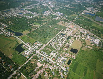
An aerial view taken from the east of the Lutheran Haven and St. Luke's properties c. 2006. The camera is aimed toward the west-southwest and the elevation is high enough so that the 417 Expressway, SR 426 and Chapman Road are all visible in the image. Note that the Lutheran Haven Nursing Home had recently been constructed (a cluster of coral rooftops), with St. Luke's Church and School to the right (north) of the Haven property. Chapman Road was "four-laned" a few years after this image was taken.
Date
c. 2006
Subject-Personal Names
Mikler, Anna Jakubcin; Tesinsky, Mary Mikler; Duda, Katie Mikler; Jakubcin, Anna Duda; Stanko, Juliana; Jakubcin, Barbara; Lukas, Maria Klimek
Coverage-Spatial
Seminole County, Fla.
Coverage-Temporal
1946
Number of Images
1
Side of Image
Front of Postcard
Repository
St. Luke's Lutheran Church and School; DSpace at St. Luke's
Repository Collection
D. Expanded Church 1993-2011;
CFM Storyline
People; Places; Social Life
Identifier
DP0020230
Rights Statement
All rights to images are held by the respective holding institution. This image is posted publicly for non-profit educational uses, excluding printed publication. For permission to reproduce images and/or for copyright information contact St. Luke’s Lutheran Church at 2021 W SR 426, Oviedo, FL 32765 or (407) 365-3408.
Digital Publisher
St. Luke's Lutheran Church, Oviedo, Fla.
Digital Reproduction Specifications
Jpeg2000 images were derived from previously scanned jpeg images.
Date Digitized
2011-2012
Recommended Citation
Duda, Ferdinand Sr., "Aerial View of Slavia, Showing Lutheran Haven and St. Luke's Properties, c. 2006" (2006). Images of Central Florida. 407.
https://stars.library.ucf.edu/cfm-images/407
Keywords
Aerial View; Lutheran Haven; St. Luke's Lutheran Church; Slavia; SR 426; Chapman Road
Accessibility Statement
This item was created or digitized prior to April 24, 2027, or is a reproduction of legacy media created before that date. It is preserved in its original, unmodified state specifically for research, reference, or historical recordkeeping. In accordance with the ADA Title II Final Rule, the University Libraries provides accessible versions of archival materials upon request. To request an accommodation for this item, please submit an accessibility request form.