

Images of Central Florida
Preview
Photographer
Unknown;
Contributors
Krivosova, Janka
Keywords
St. Luke's Lutheran School; St. Luke's Cemetery; St. Luke's Lutheran Church; Lutheran Haven; Chapman Road; State Road 426
Description
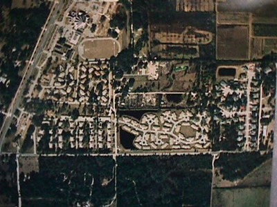
An aerial view, the photo taken sometime between the completion of St. Luke's new sanctuary (1993) and the construction of St. Luke's new two-story school facility (2000). This image also includes a view of the Lutheran Haven campus, St. Luke's Cemetery and other properties owned by the church and Lutheran Haven, immediately south of Chapman Road. The photo was taken to show "north" at the top of the image. Chapman Road (two-laned at time of photo) can be seen running across the bottom, with State Road 426, running diagonally on the left side of the photo.
Date
c. 1993-2000
Subject-Personal Names
Mikler, Anna Jakubcin; Tesinsky, Mary Mikler; Duda, Katie Mikler; Jakubcin, Anna Duda; Stanko, Juliana; Jakubcin, Barbara; Lukas, Maria Klimek
Coverage-Spatial
Seminole County, Fla.
Coverage-Temporal
1946
Number of Images
1
Side of Image
Front of Postcard
Repository
St. Luke's Lutheran Church and School; DSpace at St. Luke's
Repository Collection
St. Luke's Church Archives; D. Expanded Church 1993-2011;
CFM Storyline
People; Places; Social Life
Identifier
DP0020481
Rights Statement
All rights to images are held by the respective holding institution. This image is posted publicly for non-profit educational uses, excluding printed publication. For permission to reproduce images and/or for copyright information contact St. Luke’s Lutheran Church at 2021 W SR 426, Oviedo, FL 32765 or (407) 365-3408.
Digital Publisher
St. Luke's Lutheran Church, Oviedo, Fla.
Digital Reproduction Specifications
Jpeg2000 images were derived from previously scanned jpeg images.
Date Digitized
2011-2012
Recommended Citation
Koevenig, James Sr., "Aerial View of St. Luke's and Lutheran Haven Properties c. 1993-2000" (1993). Images of Central Florida. 430.
https://stars.library.ucf.edu/cfm-images/430
Keywords
St. Luke's Lutheran School; St. Luke's Cemetery; St. Luke's Lutheran Church; Lutheran Haven; Chapman Road; State Road 426
Accessibility Statement
This item was created or digitized prior to April 24, 2027, or is a reproduction of legacy media created before that date. It is preserved in its original, unmodified state specifically for research, reference, or historical recordkeeping. In accordance with the ADA Title II Final Rule, the University Libraries provides accessible versions of archival materials upon request. To request an accommodation for this item, please submit an accessibility request form.