

Images of Central Florida
Preview
Photographer
Unknown
Keywords
Slavia Colony
Description
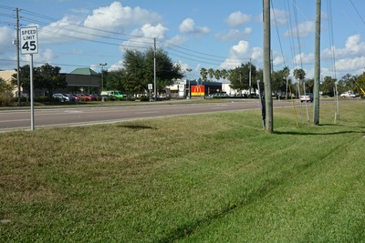
When the representatives and land agents for a group of Slovak immigrants in Ohio explored possible Central Florida sites in 1911 and recommended the area which became known as Slavia Colony, no one could possibly have foretold that the land on which they stood in this historic photograph would change so drastically in the century to come. First it was used as farmland by the settlers; the nearby railroad served to transport their crops to market. For a time the land depicted in the photo lay fallow, but it was eventually purchased by developers and the old fields became concrete parking lots for the new shopping center. The railroad tracks disappeared, to be replaced later by a hiking-biking trail. Digital images taken in 2015 show McDonald's iconic arches in the distance and a commercial listing of the businesses operating in the shopping center.
Date
2015
Coverage-Spatial
Seminole County, Fla.
Side of Image
Front of Postcard
Repository
St. Luke's Lutheran Church and School; DSpace at St. Luke's
Repository Collection
E. Centennial era Year 2012-
Identifier
DP0020048
Rights Statement
All rights to images are held by the respective holding institution. This image is posted publicly for non-profit educational uses, excluding printed publication. For permission to reproduce images and/or for copyright information contact St. Luke's Lutheran Church at 2021 W SR 426, Oviedo, FL 32765 or (407) 365-3408.
Digital Publisher
St. Luke's Lutheran Church, Oviedo, Fla.
Digital Reproduction Specifications
Jpeg2000 images were derived from previously scanned jpeg images.
Recommended Citation
Duda, Judy DeCoste; Krueger, Frederic; and Pierce, Susan, "Slavia, from Homesteads to "Home Depot": Then and Now, 2015" (2015). Images of Central Florida. 4566.
https://stars.library.ucf.edu/cfm-images/4566
Keywords
Slavia Colony
Image Location
Accessibility Statement
This item was created or digitized prior to April 24, 2027, or is a reproduction of legacy media created before that date. It is preserved in its original, unmodified state specifically for research, reference, or historical recordkeeping. In accordance with the ADA Title II Final Rule, the University Libraries provides accessible versions of archival materials upon request. To request an accommodation for this item, please submit an accessibility request form.