

Images of Central Florida
Preview
Photographer
Unknown;
Contributors
South Publishing Co.
Description
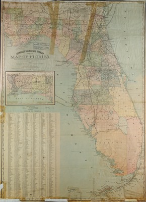
Granville's railroad and township map of Florida: a new and comprehensive map of the state of Florida, compiled from the latest official and local sources of information, by Charles Granville. Map shows county boundaries, forts, railroad lines, and steamboat line, also includes inset extension of map and an index of places. Scale [ca. 1:1,000,000] (W 85º40’--W 79º55’/N 31º05’--N 23º25’).
Date
1886
Coverage-Spatial
Florida
Coverage-Temporal
19th century
Side of Image
Front of Postcard
Repository
Rollins College
Repository Collection
Archives and Special Collections
Identifier
DP0003846; 44134648
Size of Original Image
76 x 56 cm.
Rights Statement
All rights to images are held by the respective holding institution. This image is posted publicly for non-profit educational uses, excluding printed publication. To purchase copies of images and/or for copyright information contact the respective holding institution.
Digital Publisher
Electronically reproduced by the Digital Services unit of the University of Central Florida Libraries, Orlando, 2005.
Digital Reproduction Specifications
This image was derived from an uncompressed TIFF image scanned at a minimum of 400 dpi.
Recommended Citation
Granville, Charles Augustus, "Granville's railroad and township map of Florida." (1886). Images of Central Florida. 825.
https://stars.library.ucf.edu/cfm-images/825
Accessibility Statement
This item was created or digitized prior to April 24, 2027, or is a reproduction of legacy media created before that date. It is preserved in its original, unmodified state specifically for research, reference, or historical recordkeeping. In accordance with the ADA Title II Final Rule, the University Libraries provides accessible versions of archival materials upon request. To request an accommodation for this item, please submit an accessibility request form.