

Images of Central Florida
Preview
Description
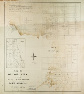
Map of Orange City and vicinity, Volusia County, Florida, including the landing at Blue Springs on the Saint John's River. Map was surveyed and drawn by Edward R. Trafford. Map contains city plan and plans for orchards in Blue Springs.
Date
1877
Subjects
Orange City (Fla.) -- Maps.; Blue Springs (Fla.) -- Maps.; Saint John's River (Fla.) -- Maps.; Land tenure -- Florida -- Orange City -- Maps.; City planning -- Florida -- Orange City.; Orange City (Fla.) --Historical geography -- Maps.; Real property -- Florida -- Orange City -- Maps.
Coverage-Spatial
Orange City (Fla.); Volusia County (Fla.); Saint John's River (Fla.); Blue Springs (Fla.)
Coverage-Temporal
19th century
Side of Image
Front of Postcard
Repository
Rollins College
Repository Collection
Archives and Special Collections
Identifier
DP0003865; 57366732
Size of Original Image
62 x 53 cm.
Rights Statement
All rights to images are held by the respective holding institution. This image is posted publicly for non-profit educational uses, excluding printed publication. To purchase copies of images and/or for copyright information contact the respective holding institution.
Digital Publisher
Electronically reproduced by the Digital Services unit of the University of Central Florida Libraries, Orlando, 2005.
Digital Reproduction Specifications
This image was derived from an uncompressed TIFF image scanned at a minimum of 400 dpi.
Recommended Citation
Trafford, Edward R., "Map and plan of Orange City and vicinity, Volusia County, Florida." (1877). Images of Central Florida. 831.
https://stars.library.ucf.edu/cfm-images/831
Accessibility Statement
This item was created or digitized prior to April 24, 2027, or is a reproduction of legacy media created before that date. It is preserved in its original, unmodified state specifically for research, reference, or historical recordkeeping. In accordance with the ADA Title II Final Rule, the University Libraries provides accessible versions of archival materials upon request. To request an accommodation for this item, please submit an accessibility request form.