
Preview
Title - Alternative
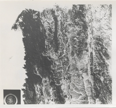
Salinas Valley Agricultural Region from Skylab 3
Keywords
Aeronautics, John F. Kennedy Space Center, NASA, Skylab 3
Photo Description
SKYLAB 3 EREP PHOTO -- A vertical view of the Salinas River Valley area south of Monterey Bay, California is seen in this Skylab 3 Earth Resources Experiments Package S190-B (five-inch Earth terrain camera) photograph taken from the Skylab space station in Earth orbit. The valley is an irrigated agricultural area, and is indicated by the dark green and light gray rectangular patterns in the center of the picture. The city of Salinas is barely visible under the cloud cover at the top (north) end of the valley. The dark mass on the left (west) side of the valley is the Santa Lucia Mountain Range. The Big Sur area is on the left and partly covered by clouds. The Diablo Range forms the dark mass in the lower right (southeast) corner of the photograph. The town of Hollister is the gray area in the dark green rectangular farm tracts which occupy the floor of the San Benito Valley in the upper right (northeast) corner of the photograph. The Salinas River flows northwestward toward Monterey Bay. The towns of Soledad, Greenfield and King City appear as gray areas along U.S. 101 in the Salinas Valley.
The geology of the area is complex and has been traced by several earthquake faultings from movement along the San Andreas and its subsidiary faults. Here, the surface expression of the San Andreas Fault can be traced from a point just west of Hollister at the contrast of dark brown and tan to a point about one inch left of the lower right (southeast) corner. Subsidiary faults are indicated by the curving trend of the rocks along the right side. The photograph will provide detailed information on land use patterns (Dr. L. Colwell, University of California, Berkeley) and fault tectonics (Dr. P. Merifield, Earth Science Associates, Inc., and Dr. M. Abdel-Gawad, Rockwell International).
Federal agencies participating with NASA on the EREP project are the Departments of Agriculture, Commerce, Interior, the Environmental Protection Agency and the Corps of Engineers. All EREP photography is available to the public through the Department of Interior's Earth Resources Observations Systems Data Center, Sioux Falls, South Dakota 57198.
Publication Date
10-30-1973
Format
image/jpeg
Number of Images
2
Side of Image
Front of Image
Publisher
National Aeronautics and Space Administration (NASA)
Original Size
8" x 10"
Identifier
DP0057714-0015a
NASA Photo Number
108-KSC-73PC-746; 73H-1058; 73HC-845; SL3-88-004
Photo Credit
National Aeronautics and Space Administration
Location
John C. Hitt Library
Department
Special Collections & University Archives
Call Number
SC 010
Digital Production Specifications
Digitized by the University of Central Florida Libraries, Digital Initiatives Unit. Jpeg images were derived from no less than 600 dpi tiffs scanned on a Copibook scanner.
Use and Reproduction
This image is posted publicly for non-profit educational uses, excluding printed publication. For permission to reproduce images and/or for copyright information, contact Special Collections & University Archives, University of Central Florida Libraries, Orlando, FL 32816, (407) 823-2576.
Additional Rights Statement
This photograph is a government publication – not subject to copyright.
Recommended Citation
"Skylab 3 View of the Salinas River Valley and San Andreas Fault" (1973). Official NASA Photographs, Vol. 3 - October 2, 1973 – February 14, 1974. 14.
https://stars.library.ucf.edu/nasa-photographs-volume-3/14
Back of Image
Keywords
Aeronautics, John F. Kennedy Space Center, NASA, Skylab 3