
Preview
Title - Alternative
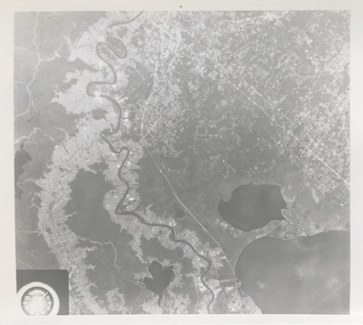
Baton Rouge to New Orleans Corridor Viewed from Skylab 3
Keywords
Aeronautics, John F. Kennedy Space Center, NASA, Skylab 3
Photo Description
SKYLAB 3 EREP PHOTO — A vertical view of southeastern Louisiana is seen in this Skylab 3 Earth Resources Experiments Package S190-B (five-inch Earth Terrain camera) infrared photograph taken from the Skylab space station in Earth orbit. The Mississippi River meanders southward through the picture from Baton Rouge at the top to the western suburbs of New Orleans. The largest body of water, Lake Pontchartrain, with its 23-mile-long causeway, is in the eastern corner of the photograph. The smaller body of water is Lake Maurepas which is connected to Lake Pontchartrain by a canal. Note the long lot farm tracts which face both the Mississippi and a former river channel (Bayou Lafourche) on the west. The long lot land grants were developed by the early French settlers and have been retained to this date. The major thoroughfare running from Baton Rouge southeastward toward New Orleans is U.S. 61. However, the most conspicuous highway between New Orleans and Baton Rouge is Interstate 10 under construction. Interstate 12 runs eastward from Baton Rouge and passes on the north side of Pontchartrain. North of Lake Maurepas is the small city of Hammond where Interstate 55 from Jackson, Mississippi connects with Interstate 12. Small communities along the river appear as white-gray areas. The unique coloration in this photograph is due to vegetation appearing as red in the color infrared film. Note the red in the long lot farms where crops occur in contrast to the gray barren areas. All EREP photography is available to the public through the Department of Interior's Earth Resources Observations Systems Data Center, Sioux Falls, South Dakota 57198.
Publication Date
10-30-1973
Format
image/jpeg
Number of Images
2
Side of Image
Front of Image
Publisher
National Aeronautics and Space Administration (NASA)
Original Size
8" x 10"
Identifier
DP0057714-0013a
NASA Photo Number
SL3-87-262; 72H-1056-73HC-843; 108-KSC-73PC-744
Photo Credit
National Aeronautics and Space Administration
Location
John C. Hitt Library
Department
Special Collections & University Archives
Call Number
SC 010
Digital Production Specifications
Digitized by the University of Central Florida Libraries, Digital Initiatives Unit. Jpeg images were derived from no less than 600 dpi tiffs scanned on a Copibook scanner.
Use and Reproduction
This image is posted publicly for non-profit educational uses, excluding printed publication. For permission to reproduce images and/or for copyright information, contact Special Collections & University Archives, University of Central Florida Libraries, Orlando, FL 32816, (407) 823-2576.
Additional Rights Statement
This photograph is a government publication – not subject to copyright.
Recommended Citation
"Skylab 3 Infrared View of Southeastern Louisiana" (1973). Official NASA Photographs, Vol. 3 - October 2, 1973 – February 14, 1974. 16.
https://stars.library.ucf.edu/nasa-photographs-volume-3/16
Back of Image
Keywords
Aeronautics, John F. Kennedy Space Center, NASA, Skylab 3