
Preview
Keywords
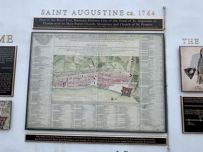
Signs, Castillo de San Marcos Fort
Abstract
Historical map from 1764 titled 'Plan of the Royal Fort,' detailing the layout of St. Augustine and Castillo de San Marcos.
Type
Image
Rights

This work is licensed under a Creative Commons Attribution-Noncommercial-No Derivative Works 4.0 License.
Recommended Citation
Howard, Wendy S., "Plan of the Royal Fort" (2022). St. Augustine 2022 Images. 7.
https://stars.library.ucf.edu/staugustine2022/7
Keywords
Signs, Castillo de San Marcos Fort
Image Location
Accessibility Statement
This item was created or digitized prior to April 24, 2027, or is a reproduction of legacy media created before that date. It is preserved in its original, unmodified state specifically for research, reference, or historical recordkeeping. In accordance with the ADA Title II Final Rule, the University Libraries provides accessible versions of archival materials upon request. To request an accommodation for this item, please submit an accessibility request form.