

Images of Central Florida
Preview
Contributors
Fisk and Co.
Description
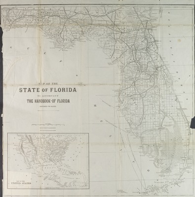
Map of the state of Florida to accompany the Handbook of Florida, revised to date, engraved by Fisk and Co.and Engravers, New York. Map shows grid, county boundaries, railroads and canals, includes inset map of the United States. Prime meridian: Washington D.C. Map scale [ca. 1:1,457,280].
Date
1890
Subjects
Florida -- Maps.; Railroads -- Florida -- Maps.; United States -- Maps.; Florida -- Administrative and political divisions -- Maps.; Steamboat lines -- Florida -- Maps.; Central America -- Maps.; West Indies -- Maps.; Florida -- Historical geography -- Maps.
Coverage-Spatial
Florida; United States
Coverage-Temporal
19th century
Side of Image
Front of Postcard
Repository
Rollins College
Repository Collection
Archives and Special Collections
Identifier
DP0003868; 44585145
Size of Original Image
53 x 53 cm.
Rights Statement
All rights to images are held by the respective holding institution. This image is posted publicly for non-profit educational uses, excluding printed publication. To purchase copies of images and/or for copyright information contact the respective holding institution.
Digital Publisher
Electronically reproduced by the Digital Services unit of the University of Central Florida Libraries, Orlando, 2005.
Digital Reproduction Specifications
This image was derived from an uncompressed TIFF image scanned at a minimum of 400 dpi.
Recommended Citation
Longmans, Green, and Co., "Map of the state of Florida." (1890). Images of Central Florida. 833.
https://stars.library.ucf.edu/cfm-images/833
Accessibility Statement
This item was created or digitized prior to April 24, 2027, or is a reproduction of legacy media created before that date. It is preserved in its original, unmodified state specifically for research, reference, or historical recordkeeping. In accordance with the ADA Title II Final Rule, the University Libraries provides accessible versions of archival materials upon request. To request an accommodation for this item, please submit an accessibility request form.