

Images of Central Florida
Preview
Contributors
Swift, W.H. (William Henry), 1800-1879.
Description
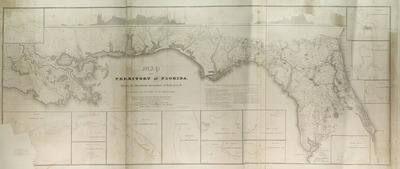
Topographical map of the territory of Florida from its northern boundary to latitude 2730'N, connected with the delta of the Mississippi.and The map was annexed to the report of the Board of Internal Improvement dated February 19th 1829 relating to the canal completed to connect the Atlantic with the Gulf of Mexico, and describing the inland navigation parallel to the coast from the Mississippi to the Bay of Espiritu Santo, and from St. Mary's Harbour to St. Augustine, drawn and compiled by W.H. Swift. Relief shown pictorially, by profile (inset) and soundings. Map contains insets (11)and Entrances to various bays, etc.and scale [1:63,360]and St. Mary's Harbour--St. John's River--St. Augustine--St. Georges Sound (3)and-Ocklockony Bay--Appalachicola Bay--St. Jospeh's Bay--St. Andrew's Sound--Pensacola Bay--St. Rosa--Mobile Bay, and the Gulf of Mexico; scale [1:33,929,200]and Also contains inset of water-levels. Map was compiled under the direction of the Board of Internal Improvement from charts, surveys, and drawings by G. Gaulds, W.T. Poussin, J. Kearney, et al. Map scale [1:696,960]andand
Date
1829
Subjects
Florida -- Maps.; Mexico, Gulf of -- Maps; Hydrogeological surveys -- Florida -- Maps.; Florida -- History -- 1821-1865 -- Maps.; Florida -- Topographic maps.; Indian reservations -- Florida -- Maps.; Florida -- Historical geography -- Maps.
Coverage-Spatial
Florida; Gulf of Mexico
Coverage-Temporal
19th century
Side of Image
Front of Postcard
Repository
Rollins College
Repository Collection
Archives and Special Collections
Identifier
DP0003925; 7764372
Size of Original Image
68 x 166 cm.
Rights Statement
All rights to images are held by the respective holding institution. This image is posted publicly for non-profit educational uses, excluding printed publication. To purchase copies of images and/or for copyright information contact the respective holding institution.
Digital Publisher
Electronically reproduced by the Digital Services unit of the University of Central Florida Libraries, Orlando, 2005.
Digital Reproduction Specifications
This image was derived from an uncompressed TIFF image scanned at a minimum of 400 dpi.
Recommended Citation
United States. Board of Internal Improvement., "Map of the territory of Florida from its northern boundary to lat. 2730'N, connected with the delta of the Mississippi." (1829). Images of Central Florida. 839.
https://stars.library.ucf.edu/cfm-images/839
Accessibility Statement
This item was created or digitized prior to April 24, 2027, or is a reproduction of legacy media created before that date. It is preserved in its original, unmodified state specifically for research, reference, or historical recordkeeping. In accordance with the ADA Title II Final Rule, the University Libraries provides accessible versions of archival materials upon request. To request an accommodation for this item, please submit an accessibility request form.